Leading Underwater Survey Drones for UK Waters in 2025: Expert Comparison Guide
Published on Wednesday, 2 April 2025
The demand for precise hydrographic surveying across British waters has never been greater, with applications ranging from infrastructure inspections beneath our canal systems to comprehensive marine environmental assessments. Modern underwater survey drones have fundamentally transformed how professionals gather crucial data in challenging aquatic environments, enabling everything from subsea cable monitoring to archaeological exploration of our historic waterways. These remotely operated vehicles combine exceptional manoeuvrability with sophisticated sensor technology, making them indispensable for civil engineers, environmental consultants, and marine researchers throughout the UK. Whether you're tasked with inspecting aging harbour infrastructure, conducting environmental impact assessments, or documenting submerged historical sites, selecting the right hydrographic drone can significantly enhance both the efficiency and accuracy of your fieldwork. This comprehensive guide examines five of the most capable systems currently available to UK professionals, helping you identify the ideal solution for your specific surveying requirements and operational constraints.
Top Picks Summary
QYSEA FIFISH V6 PLUS
The QYSEA FIFISH V6 PLUS earns a top spot in UK hydrographic survey work for 2025 by pairing 4K imaging, six-thruster maneuverability and a competitive price that suits coastal and inland teams needing high-resolution visual inspection without industrial capital expenditure. Compared with heavier or more modular systems on this list, it offers exceptional out-of-the-box imaging and portability versus the Deep Trekker DTG3 and greater turnkey usability than a stock BlueROV2, while remaining more affordable than enterprise-grade alternatives.
Chasing M2 Pro
The Chasing M2 PRO MAX stands out for its extended endurance, high payload capacity and ability to carry larger survey sensors—making it a technically flexible choice for midsized hydrographic projects around UK coasts and inland waterways. Financially positioned between prosumer models and industrial-class ROVs, it offers better sensor-carrying capability than the FIFISH and MITO yet at a lower acquisition cost than the Deep Trekker DTG3, while providing a more integrated, ready-to-deploy solution than a heavily customised BlueROV2.

BlueROV2
BlueROV2 is prized in UK survey circles in 2025 for its open architecture and modular ecosystem, allowing research institutions and contractors to customise sensor suites (multibeam, USBL, camera upgrades) at relatively low incremental cost. While it may require more user integration and field setup than turnkey systems like Chasing or QYSEA, its long-term affordability and unparalleled flexibility make it the go-to option for teams that prioritise bespoke hydrographic instrumentation over out-of-the-box simplicity.

Deep Trekker DTG3
The Deep Trekker DTG3 is the market leader for commercial hydrographic surveys in the UK due to its rugged industrial design, certified handling features, professional service/support and compatibility with high-end sonar payloads—traits that reduce operational risk on critical projects. Although it carries a premium price relative to the other entries, that investment buys proven reliability, regulatory-friendly features and lower downtime compared with cheaper alternatives like the FIFISH or Navatics MITO, making it ideal for regulated or high-liability survey work.

£20000-45000 GBP
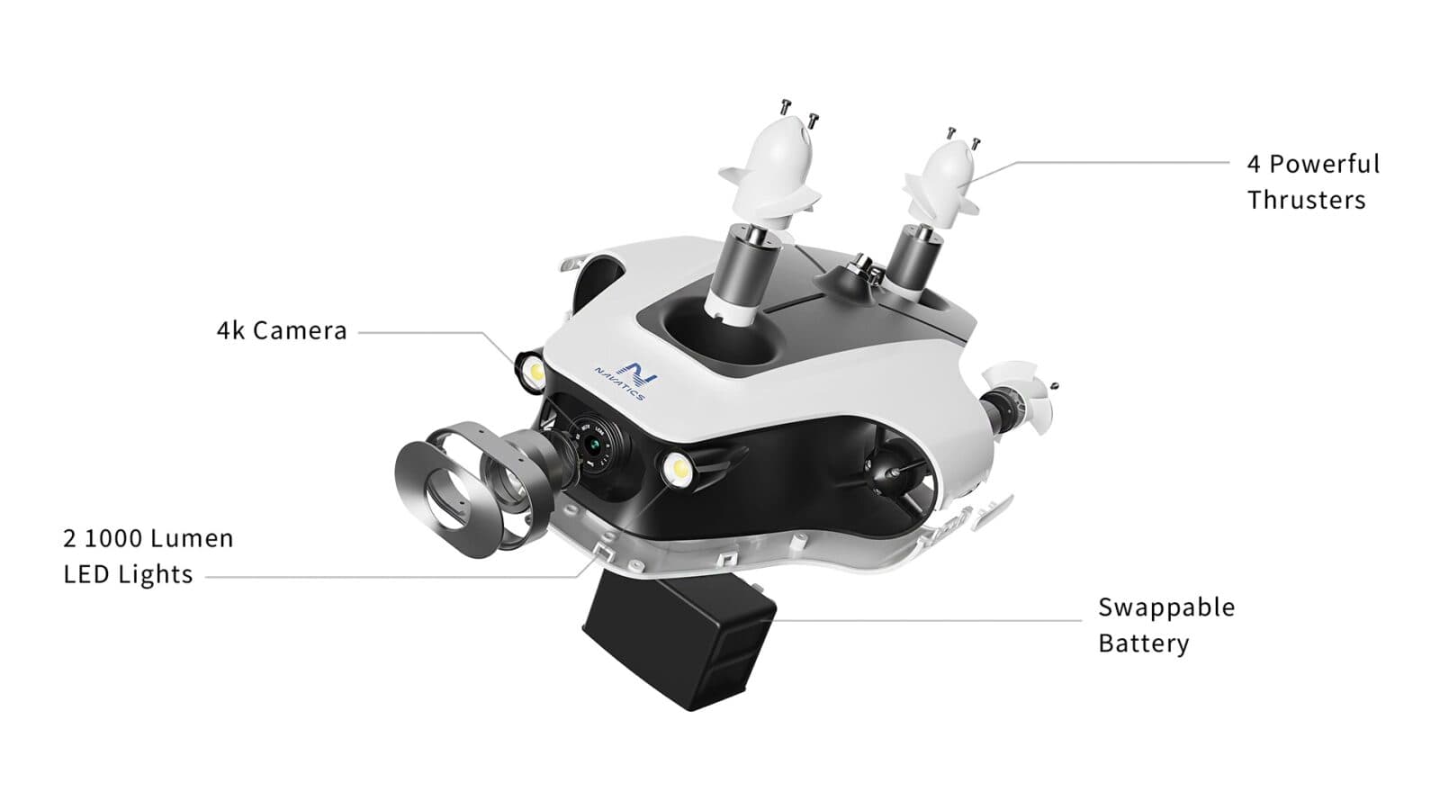
Navatics MITO
Navatics MITO is valued for its compact form factor, strong autonomy and AI-assisted navigation that enable rapid, repeatable shallow-water surveys and inspections around UK ports and marinas. It is one of the more affordable, quick-deployment platforms on this list and excels where speed and autonomy matter, though it concedes payload capacity, depth rating and raw imaging performance to larger systems such as the Chasing M2 PRO MAX and Deep Trekker DTG3.
These leading hydrographic survey drones distinguish themselves through robust construction engineered for demanding UK water conditions, advanced sonar and optical sensor integration for precise subsea mapping, impressive operational depth ratings exceeding standard freshwater requirements, and sophisticated stabilisation systems ensuring reliable performance in challenging tidal conditions.
Understanding Hydrographic Survey Drones: Essential Knowledge for UK Practitioners
Hydrographic survey drones represent a significant technological advancement in aquatic data collection, offering distinct advantages over traditional surveying methodologies. These sophisticated unmanned systems utilise integrated sensor arrays including multibeam sonar, side-scan sonar, optical cameras, and specialised measurement instruments to generate accurate three-dimensional representations of underwater terrain and subsea infrastructure.
Sonar Integration: Advanced multibeam and side-scan sonar systems enable detailed seafloor mapping even in turbid British waters with limited visibility
Operational Depth: Professional-grade systems typically operate at depths between 300-600 metres, suitable for most UK coastal and riverine applications
Battery Performance: Extended operational runtime between 4-8 hours enables comprehensive survey coverage across substantial geographic areas
Real-time Data Transmission: Live sonar feeds and camera imagery facilitate immediate decision-making during active survey operations
Regulatory Compliance: Systems designed for UK operations meet maritime authority requirements and environmental protection standards
Data Processing: Integrated software generates georeferenced survey data compatible with GIS platforms and professional surveying applications
Deployment Flexibility: Compact portable designs enable rapid deployment from various vessel types and shoreline locations
Maintenance Requirements: Professional-grade systems demand periodic servicing but offer exceptional longevity with proper care protocols
Frequently Asked Questions
Which underwater survey drone suits UK hydrographic teams best?
QYSEA FIFISH V6 PLUS is a top pick for UK hydrographic survey work in 2025, thanks to its 4K camera with stabilised gimbal, six-thruster manoeuvrability, and rated 100 m depth for coastal and nearshore inspection tasks.
Does BlueROV2 support modular sensors for hydrographic surveys?
BlueROV2 has an open-frame, highly modular platform with wide third-party sensor compatibility including sonars, plus a configurable thruster layout for reliable station-keeping for precise survey work at ~100 m depth.
How does Chasing M2 PRO MAX pricing compare for UK buyers?
The provided info doesn’t include a price for Chasing M2 PRO MAX, but it does list an extended transect capability via optional long tethers and a modular payload bay for integrating smaller sonars and auxiliary sensors.
What warranty coverage is offered for these underwater drones?
The provided details don’t mention any warranty duration for QYSEA FIFISH V6 PLUS, Chasing M2 PRO MAX, or BlueROV2, so I can’t confirm coverage periods from the supplied data.
Conclusion
Selecting an appropriate hydrographic survey drone depends fundamentally on understanding your specific operational requirements, budget constraints, and the particular characteristics of your surveying environment. The five systems reviewed here represent the current pinnacle of underwater survey technology available to UK practitioners, each bringing distinct advantages to different application scenarios. Whether you prioritise exceptional battery endurance for extended surveys, superior sensor accuracy for detailed mapping, or straightforward operational ease for rapid deployment, there exists a viable option within this selection. We recommend carefully evaluating your project specifications against each system's capabilities, and where possible, consulting directly with suppliers regarding trial opportunities or demonstration sessions. Should you require additional information about particular models or wish to explore further resources related to hydrographic surveying practices, our comprehensive search function offers access to detailed technical specifications and user reviews. Your investment in quality survey equipment today will undoubtedly yield substantial returns in data quality and operational efficiency across your future projects.