Best Drone Technology for Crop Surveillance: UK Agricultural Solutions 2026
Published on Tuesday, 3 February 2026
Modern farming demands sophisticated tools to maintain competitiveness, and agricultural surveillance drones have emerged as game-changers across the United Kingdom's diverse farming regions. These intelligent unmanned aircraft systems capture high-resolution multispectral imagery, enabling farmers to monitor field conditions with unprecedented precision. From detecting nutrient deficiencies and water stress to identifying pest infestations before they become widespread problems, drone technology transforms how British agricultural professionals approach crop management. Whether you're managing smallholdings in the Cotswolds, large-scale operations in East Anglia, or specialist farming ventures in Scotland, precision agriculture drones deliver actionable intelligence that directly impacts yield performance and resource efficiency. The transition towards data-driven farming practices reflects broader shifts in UK agriculture, where environmental stewardship and economic viability must work hand in hand. By capturing detailed aerial surveys across multiple growing seasons, farmers gain comparative insights that inform fertiliser application, irrigation scheduling, and pest management strategies—ultimately reducing input costs whilst maintaining sustainable productivity standards.
Top Picks Summary
DJI Agras T40
The DJI Agras T40 ranks as a market leader for UK arable and mixed farms in 2026 because it combines heavy-duty spraying capacity with integrated mapping sensors and RTK positioning, letting operators both treat and survey crops with one platform. Compared with the lighter survey-focused drones on this list, the T40 delivers scale and operational savings on large holdings — its higher upfront cost is offset by reduced contractor bills and the ability to pair mapping data directly with variable-rate application workflows.

DJI Mavic 3 Multispectral
The DJI Mavic 3 Multispectral is a state-of-the-art drone designed specifically for agricultural and environmental monitoring. It features dual cameras with a multispectral sensor that captures RGB and multispectral data simultaneously, enabling precise crop analysis and health assessments. This drone stands out for its extended flight time and robust software integration, making it a favorite among precision farming professionals. Its lightweight design and high-level automation facilitate easy deployment and data collection.

5000-7000$
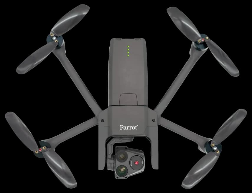
Parrot Anafi USA
Parrot Anafi USA holds a best-in-class position for compact, inspection-oriented agricultural mapping in the UK thanks to its high-resolution zoom, thermal capability and lightweight, easy-to-deploy design that suits small-to-medium farms and agronomists on the move. Financially it undercuts the fixed-wing mapping systems and heavy sprayers while bringing specialist sensors that complement larger platforms — ideal for targeted scouting, disease detection and lower-cost routine surveys.
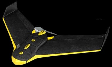
senseFly eBee X
The senseFly eBee X is the technical leader for large-area, high-precision photogrammetry across UK farmland in 2026, offering long endurance, fixed-wing efficiency and RTK/PPK workflows that lower per-hectare survey costs and maximize mapping accuracy compared with multi-rotor options. While its purchase price is higher than handheld quadcopters, the eBee X outperforms them on productivity and total-cost-of-ownership for repeated, hectare-scale mapping tasks, making it the preferred choice for contractors and large estates.
DJI Phantom 4 RTK
The DJI Phantom 4 RTK remains a market leader for precision, small-field mapping and agronomic surveys in the UK because it combines sub-decimetre geolocation, a familiar DJI workflow and a relatively low entry price for RTK-capable imagery. It does not match the area throughput of fixed-wing systems or the operational multi-role capability of the Agras T40, but its affordability and ease of use make it the go-to option for consultants and farms needing fast, centimetre-accurate maps without heavy investment.
These leading agricultural drone systems distinguish themselves through advanced multispectral sensors that detect crop stress invisible to human observation, rugged designs suited to variable British weather conditions, extended battery capabilities enabling large field coverage, and sophisticated data analytics platforms that transform raw imagery into practical management insights.
Understanding Agricultural Drone Technology
Agricultural drones represent the intersection of aerospace engineering, environmental science, and farm management expertise. These systems employ multispectral cameras capturing data across specific light wavelengths, revealing plant health indicators that guide targeted interventions.
Multispectral sensors detect normalised difference vegetation index (NDVI) patterns revealing crop stress before visual symptoms appear
Real-time ortho-mosaic generation creates accurate field maps compatible with precision application equipment
Weather resistance and flight stability enable reliable operation across typical UK growing seasons
CAA compliance and insurance-approved operation ensure regulatory alignment and risk management
Integration with farm management software streamlines data analysis and decision implementation workflows
Frequently Asked Questions
What is the best drone technology for crop surveillance in UK in 2026?
As of June 2026, DJI Agras T40 is the top choice for drone technology for crop surveillance in UK. The DJI Agras T40 ranks as a market leader for UK arable and mixed farms in 2026 because it combines heavy-duty spraying capacity with integrated mapping sensors and RTK positioning, letting operators both treat and survey crops with one platform. Compared with the lighter survey-focused drones on this list, the T40 delivers scale and operational savings on large holdings — its higher upfront cost is offset by reduced contractor bills and the ability to pair mapping data directly with variable-rate application workflows.
What are the key features of DJI Agras T40?
DJI Agras T40 features: High-capacity 40 L tank and configurable spray/granule release for large-field application, RTK-enabled guidance and obstacle-sensing radar for precise, automated treatment runs, Robust octocopter design with foldable arms and industrial-grade payload support.
What are the benefits of DJI Agras T40?
The main benefits include: Massive payload — field-guzzler, Fast coverage — acre-eater, All-weather ready — rainproof.
How does DJI Agras T40 compare to DJI Mavic 3 Multispectral?
Based on June 2026 data, DJI Mavic 3 Multispectral has a higher rating (4.8/5 vs 4.4/5). However, DJI Agras T40 offers competitive value with High-capacity 40 L tank and configurable spray/granule release for large-field application, making it a better choice for those who prioritize these features.
Conclusion
The deployment of advanced drone systems represents a significant investment in British agricultural innovation, yet the returns consistently justify the expenditure through improved decision-making and optimised farm management. Each platform featured in this guide brings distinct capabilities to the table, whether through superior sensor technology, extended flight endurance, or intuitive data processing workflows. The right choice depends on your specific farming enterprise, the scale of your operations, and your existing technical infrastructure. As regulations governing agricultural drone use continue to evolve within the UK's Civil Aviation Authority framework, operators benefit from selecting established platforms with proven compliance records and manufacturer support. We encourage farmers and agronomists to evaluate these solutions against your operational requirements, consulting with local agricultural advisors and technology providers who understand regional growing conditions. Your progression towards precision agriculture begins with understanding how these tools can integrate into your existing farm management systems.