Essential Navigation and Emergency Equipment for UK Explorers in 2026: Trusted Tools for Wilderness Safety, Route Finding, and Remote Communication
Published on Thursday, 26 February 2026
Navigating Britain's diverse landscapes—from Scottish highlands to Cornish coastal paths, Lake District fells to Welsh moorlands—demands reliable equipment that performs in unpredictable weather and challenging terrain. This comprehensive guide examines the navigation and safety tools that outdoor professionals, mountain rescue teams, and serious adventurers depend on throughout 2026. We've curated eight essential devices spanning traditional navigation aids like precision compasses and detailed topographic maps, through to cutting-edge satellite communicators and personal locator beacons. UK conditions present unique challenges: dense cloud cover obscuring landmarks, variable mobile signal in remote valleys, sudden weather deterioration on exposed ridges, and the critical need for rapid emergency response in isolated areas. Our selection prioritises robust construction withstanding British winter conditions, extended battery performance for multi-day expeditions, comprehensive offline mapping for areas beyond network coverage, and proven reliability when visibility drops or signal fails. Whether you're a fell runner tackling the Pennines, a sea kayaker exploring Scottish lochs, a rural farmer monitoring remote land, or a professional mountain guide, these tools bridge the gap between confident exploration and genuine security in the outdoors.
Top Picks Summary
The Suunto MC-2G Global stands out as the technical leader for 2025, offering a true global needle, precise sighting mirror and competition-grade accuracy that make it the safest choice for complex UK terrain and travel between hemispheres. It carries a higher price than the budget-focused Suunto A-30L and lighter Silva Race Jet, but the MC-2G's precision and build reduce navigational errors and downtime, representing excellent cost-per-performance for serious racers and leaders.
£100-140 GBP
The Garmin Fenix 7X Sapphire Solar is the premium pick for UK remote‑trail safety, delivering industry-leading battery life, multi-band GNSS and full topographic mapping beneath a scratch-resistant sapphire lens with solar trickle-charge for extended expeditions. It earns its top spot by combining the most comprehensive navigation and safety toolset — including advanced route guidance and incident detection — though that capability comes at a higher price and larger footprint compared with Garmin's more affordable Instinct 2X Solar and the lighter, altimeter-focused Suunto Vertical.
£799-999 GBP
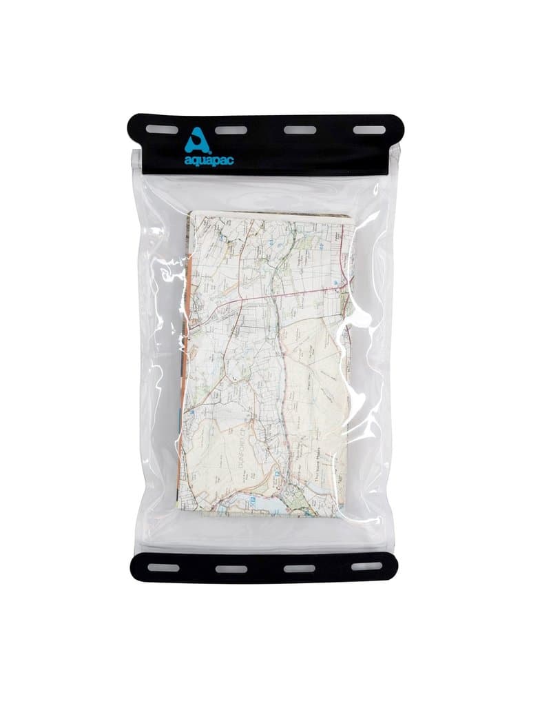
Aquapac Kaituna Waterproof Map Case
The Aquapac Kaituna is a specialist waterproof map case widely used by paddlers and search teams in the UK for its fully submersible welds and flexible clear window that maintains touchscreen access in wet conditions. More affordable than premium Ortlieb options yet technically superior to basic Highlander cases, it strikes a practical balance for users who need guaranteed waterproofing without premium bike-bag features.
These navigation and emergency devices stand apart through their proven performance in challenging British weather, comprehensive offline functionality for signal-dead zones, rapid deployment in genuine emergencies, and acceptance by professional mountain rescue and maritime authorities across the UK. Each has been selected for reliability under real-world conditions rather than laboratory specifications.
Understanding Navigation and Safety Equipment for UK Outdoor Activities
Modern outdoor navigation combines traditional skills with contemporary technology. Compasses and topographic maps remain fundamental tools that never require batteries or signal coverage, essential when you venture beyond mobile networks into Britain's wilderness areas. GPS units and dedicated mapping devices add precision to route-finding and create electronic breadcrumb trails recording your journey. Satellite communicators and personal locator beacons serve entirely different purposes—enabling two-way contact with emergency services or base camps when mobile networks simply don't exist, particularly in Scottish highlands, Welsh mountains, and Lake District valleys. UK conditions demand careful equipment selection: devices must withstand wet environments, perform reliably in cold temperatures, and offer sufficient battery life for multi-day trips without resupply. Understanding when to use each tool—map reading for general navigation, GPS for precise waypoints, satellite communication for genuine emergencies—develops well-rounded outdoor competency.
Compass and map skills remain foundational; modern technology supplements rather than replaces these essential abilities
Offline maps are critical in UK remote areas where Ordnance Survey coverage is sparse and mobile signal unreliable
Satellite communicators bridge the gap between exploration and safety by enabling contact from locations where phones cannot connect
Personal locator beacons should be reserved for life-threatening emergencies and trigger professional rescue responses
British weather requires equipment rated for wet conditions; waterproofing and sealed electronics improve reliability during expeditions
Battery performance varies significantly with temperature; devices rated for cold weather testing provide more consistent function in winter
Regular practice with navigation tools during daylight, good-weather trips builds competence for emergency situations
Professional guides and rescue teams favour combinations of traditional navigation with satellite backup rather than relying on single systems
Keeping equipment well-maintained, testing devices regularly, and understanding their limitations prevents failures when most needed
Frequently Asked Questions
What is the best essential navigation and emergency equipment explorers in UK in 2026?
As of June 2026, Suunto MC-2G Global Compass is the top choice for essential navigation and emergency equipment explorers in UK. The Suunto MC-2G Global stands out as the technical leader for 2025, offering a true global needle, precise sighting mirror and competition-grade accuracy that make it the safest choice for complex UK terrain and travel between hemispheres. It carries a higher price than the budget-focused Suunto A-30L and lighter Silva Race Jet, but the MC-2G's precision and build reduce navigational errors and downtime, representing excellent cost-per-performance for serious racers and leaders.
What are the key features of Suunto MC-2G Global Compass?
Suunto MC-2G Global Compass features: Global needle design for reliable use across hemispheres, Sighting mirror and clinometer enable precise bearings and slope measurements, Clear baseplate with magnifier and multiple map scales for detailed navigation.
What are the benefits of Suunto MC-2G Global Compass?
The main benefits include: Global needle (any-hemisphere), Mirror sighting (pinpoint), Accurate clinometer.
How does Suunto MC-2G Global Compass compare to Garmin Fenix 7X Sapphire Solar?
Based on June 2026 data, Suunto MC-2G Global Compass is rated 4.7/5 while Garmin Fenix 7X Sapphire Solar is rated 4.6/5. Both are excellent choices, but Suunto MC-2G Global Compass stands out for Global needle design for reliable use across hemispheres.
Conclusion
Selecting appropriate navigation and safety equipment represents a fundamental investment in your outdoor capability and peace of mind. The tools featured here reflect what experienced British adventurers, professional guides, and rescue services actually use when conditions matter most. Each device addresses specific scenarios you might encounter—from route-finding during navigation errors to emergency communication when conventional networks fail. The combination of traditional map-reading skills with modern technology creates the most resilient approach to wilderness safety. As you prepare for expeditions across the UK's varied terrain, consider which tools match your typical activities, your risk tolerance, and the remote areas you frequent. Start with foundational items like compass and detailed maps, then add satellite communication capability for serious backcountry work. Visit our detailed product reviews and comparisons to explore specifications, battery life ratings, offline map coverage, and user experiences from British conditions. Your safety decisions today directly influence your confidence and capability tomorrow.