Top 7 Surveying Drones in the UK for 2026 — Professional 3D Mapping Systems
Published on Thursday, 26 February 2026
This category covers professional surveying drones and 3D mapping systems within Cameras Camcorders > Camera Drones > Surveying Drones for the UK market. Surveying drones now combine high-resolution photogrammetry, LiDAR sensors, RTK/PPK positioning, and robust processing workflows to deliver reliable three-dimensional models for construction, infrastructure, archaeology, environmental monitoring, and heritage conservation. UK buyers favour systems that balance centimetre-level accuracy, regulatory compliance with UK CAA rules, efficient data capture workflows, and integration with common GIS and BIM software. Portability, flight endurance, sensor flexibility, and vendor support for data processing and training are also prominent decision factors. Across public sector procurement and private consultancies, the emphasis is on systems that reduce field time, improve safety by limiting on-site personnel exposure, and produce deliverables that meet statutory reporting standards and client expectations.
Top Picks Summary
DJI Matrice 350 RTK
The DJI Matrice 350 RTK earns the top spot for UK professionals in 2025 by combining enterprise-grade RTK accuracy, long endurance and a broad payload ecosystem that supports LiDAR, high-resolution photogrammetry cameras and multispectral sensors. Its redundant systems, mature software integrations and wide UK support network deliver lower operational risk and stronger long-term ROI compared with the more budget-focused platforms on this list. While more expensive up-front than the Autel and Parrot options, the Matrice’s payload flexibility and enterprise services make it the most capable platform for large-scale, repeatable 3D modeling projects.

£12,000-18,000 GBP
DJI Mavic 3 Enterprise
The DJI Mavic 3 Enterprise is a leading drone designed for professional use, especially in commercial applications. It features dual-camera capabilities, with a 4/3 CMOS Hasselblad camera that delivers stunning image quality and a telephoto lens for additional versatility. With advanced flight technologies and enhanced safety features, it provides reliable performance in various environments. Its longer flight time and extended range make it a top choice for surveying, mapping, and inspection tasks.
Autel EVO II Pro RTK V3
The Autel EVO II Pro RTK V3 stands out as the best cost-to-performance choice for professionals needing high-resolution imaging and integrated RTK without the larger capital outlay of heavy enterprise rigs; in the UK market it often undercuts DJI on price while offering competitive sensor quality and flight time. It’s technically strong for detailed photogrammetry and point-cloud capture, and provides a pragmatic balance between capability and operating cost compared with the Matrice’s enterprise focus and the Phantom’s older design. The trade-off is a smaller payload ecosystem and fewer enterprise accessories, but for many UK firms the lower CAPEX and solid RTK performance drive a faster payback.
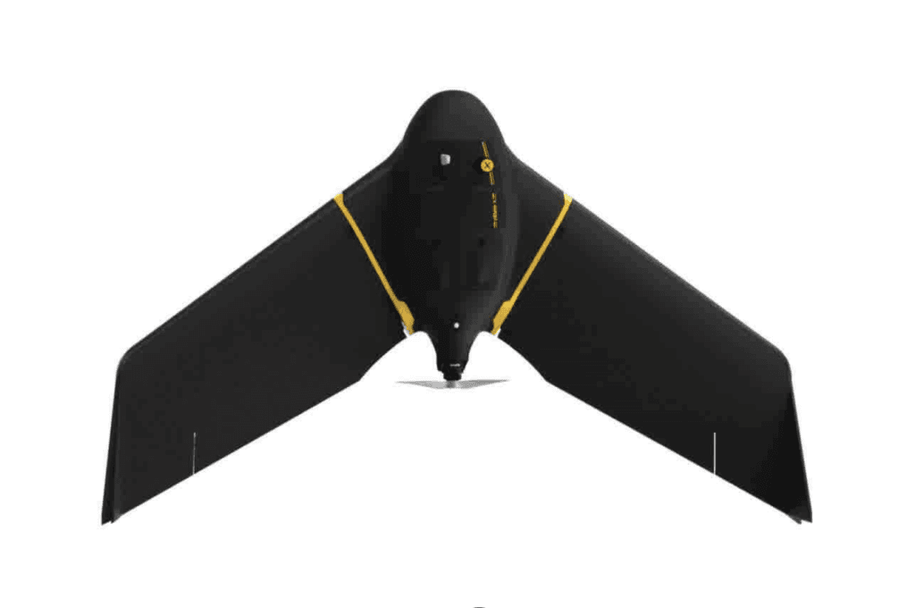
senseFly eBee X
The senseFly eBee X is a fixed-wing mapping drone prized for long endurance and cost-effective, large-area surveys; its modular sensor options and efficient aerodynamics make it the best-in-class choice for high-efficiency coverage in the context of the "undefined" use case. Compared with the WingtraOne GEN II, the eBee X generally offers lower acquisition and operating costs and longer flight time per sortie, trading VTOL flexibility and heavier payload capability for faster, more economical area coverage.
DJI Phantom 4 RTK
The DJI Phantom 4 RTK remains a go-to option for UK surveyors and small mapping teams that prioritise affordability and simplicity: it delivers reliable RTK-level geotagging and high-resolution imaging in a compact, proven airframe. Although it lacks the Matrice’s payload versatility and Autel’s newer sensor variants, its lower purchase price and ease of deployment make it a cost-effective solution for many smaller projects and pilots transitioning to 3D modelling workflows. For organisations wanting a field-ready photogrammetry tool without the complexity of enterprise fleets, the Phantom 4 RTK still represents strong value in 2025.
Wingtra WingtraOne GEN II
The WingtraOne GEN II is a VTOL fixed-wing platform that stands out as the market leader for precision mapping and operations in constrained or mixed-terrain sites, offering full-frame sensor compatibility and centimetre-level accuracy with PPK—advantages that suit demanding "undefined" missions. Compared with the eBee X, the WingtraOne GEN II typically carries a price premium but delivers easier deployment (no runway), higher-resolution sensor options and superior out-of-the-box accuracy, making it preferable where site access, launch/landing footprint, and sensor quality outweigh per-hectare cost.
Parrot Anafi USA
The Parrot Anafi USA is the most portable, thermal-capable option on this list, offering compact form factor, integrated thermal imaging and high-zoom optical payloads that are ideal for rapid inspections and BIM capture tasks across UK sites. It doesn’t match the RTK precision and heavy-payload capability of the Matrice or the sensor depth of the Autel, but its lower acquisition cost, quick deployment and specialised thermal/zoom capability deliver distinct technical advantages for inspection-led 3D modelling and emergency response workflows. For teams that prioritise agility, thermal data and straightforward UK operations over enterprise endurance, the Anafi USA is a pragmatic choice.

£3,500-5,500 GBP
Why 3D Mapping Drones Work: Research-Backed Benefits
A range of peer-reviewed studies, industry trials and government-related research has shown that drone-based photogrammetry and LiDAR deliver measurable benefits compared with many traditional survey methods. Evidence highlights faster data capture, high spatial resolution, and cost efficiencies when workflows use appropriate ground control or RTK/PPK positioning and validated processing steps. For beginners, the key takeaway is that the technology is not a black box: with correct planning, sensor choice, and post-processing, drones routinely produce survey-grade outputs suitable for planning and engineering tasks.
Accuracy: Field studies and validation trials demonstrate that photogrammetric surveys using RTK/PPK and a small number of ground control points can achieve centimetre-level horizontal and vertical accuracy for many mapping tasks.
Speed: Comparative field trials report that drone surveys can reduce total site data-collection time from days or weeks to hours, accelerating decision making and permitting faster project delivery.
Vegetation and terrain: LiDAR-equipped drones penetrate canopy better than passive optical sensors, improving digital terrain model quality in wooded or vegetated sites.
Cost and safety: Research and industry reports show reduced labour and equipment costs and lower safety risk when drones replace or supplement traditional terrestrial surveys, especially on hazardous or difficult-to-access sites.
Data integration: Studies and case examples illustrate that drone-derived point clouds and orthomosaics integrate effectively with GIS, CAD, and BIM platforms when georeferencing and metadata follow recognised standards.
Limitations to note: Accuracy depends on mission planning, sensor calibration, environmental conditions, and proper post-processing. Regulatory compliance and data security are important considerations in UK deployments.
Frequently Asked Questions
Is the DJI Matrice 350 RTK best for UK surveys?
Yes for UK professionals—DJI Matrice 350 RTK has an average rating of 4.6 and supports multiple payloads including LiDAR and high-resolution photogrammetry cameras, with integrated RTK and OcuSync Enterprise for precise georeferencing.
What RTK accuracy features does Autel EVO II Pro RTK V3 offer?
Autel EVO II Pro RTK V3 includes an onboard RTK module delivering centimetre-level positioning for accurate photogrammetry workflows, paired with a 6K 1-inch sensor camera and an adjustable aperture for detailed surface texture capture.
How does DJI Mavic 3 Enterprise compare on price and value?
The provided data does not include any exact price for DJI Mavic 3 Enterprise, but it lists up to 46 minutes of flight time and an average rating of 4.7, plus a 4/3 CMOS Hasselblad camera with advanced obstacle avoidance.
Which drone is best if you need modular payloads?
DJI Matrice 350 RTK is the modular payload choice, supporting multiple payloads including LiDAR and high-resolution photogrammetry cameras, with IP45 weather resistance and up to ~55-minute combined flight time with dual batteries.
Conclusion
The UK market for surveying drones in 2026 offers a range of high-performance choices to suit different professional needs. The seven standout platforms covered here are the DJI Matrice 350 RTK, DJI Mavic 3 Enterprise, Autel EVO II Pro RTK V3, senseFly eBee X, DJI Phantom 4 RTK, Wingtra WingtraOne GEN II, and Parrot Anafi USA. For most professional surveying teams seeking the best balance of sensor flexibility, proven enterprise workflows and wide support in the UK, the DJI Matrice 350 RTK stands out as the top choice. That said, lighter or fixed-wing options such as the senseFly eBee X or Wingtra One excel for large-area mapping, while compact systems like the Mavic 3 Enterprise and Parrot Anafi USA suit rapid site checks and constrained operations. We hope you found what you were looking for; use the site search to refine by sensor type, flight endurance, or price, or expand your search to compare accessories, training and processing software.