Top 7 Topographic Survey Drones in the UK — 2026 Guide
Published on Thursday, 26 February 2026
Topographic survey drones within Cameras Camcorders > Camera Drones > Surveying Drones have become essential tools for UK professionals who need fast, accurate terrain data and elevation mapping. From detailed orthomosaics used in planning applications to high-resolution digital elevation models for civil engineering, these unmanned aerial systems shorten field time while improving data quality across England, Wales, Scotland, and Northern Ireland. UK users choose platforms that combine centimetre-level positioning (RTK/PPK), robust sensors such as LiDAR or high-resolution photogrammetric cameras, long endurance and reliable flight performance, and seamless output into GIS and CAD workflows. Regulatory oversight by the Civil Aviation Authority and growing availability of commercial support and training have helped established firms and independent consultants adopt drone surveying for projects ranging from infrastructure, environmental assessments and agricultural management to geological and coastal studies.
Top Picks Summary
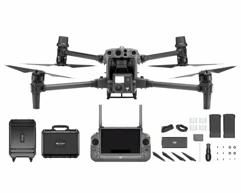
DJI Matrice 350 RTK
The DJI Matrice 350 RTK holds the market-leader spot for 2025 Britain's topographic surveying work thanks to its industrial-grade build, long endurance, versatile payload bay and integrated RTK/PPK workflows that cut field-to-deliverable time. Compared with lighter platforms on this list, the M350's higher up-front cost is offset by greater productivity on large sites and superior compatibility with third-party LiDAR and multispectral sensors, making it the most cost-effective choice for repeat commercial surveying contracts.

DJI Mavic 3 Enterprise RTK
The DJI Mavic 3 Enterprise RTK is highlighted for marrying RTK-grade positioning with extreme portability, ideal for rapid-response and constrained-access topographic surveys across Britain where travel and deployment speed reduce project cost. It sits between the Phantom and M350 in capability—offering superior sensor options and mobility compared with the Phantom, and far lower logistics cost than the M350—making it the best choice when quick, accurate coverage and minimal crew are priorities.

DJI Phantom 4 RTK
The DJI Phantom 4 RTK remains a best-in-class choice for small-to-medium topographic jobs in Britain where accuracy and budget matter, delivering centimetre-level geotagging in a compact, single-sensor package. While it lacks the M350's payload flexibility and the EVO II RTK's higher-resolution imaging, its lower purchase price and a mature, streamlined photogrammetry workflow make it a financially sensible option for surveyors focused on orthophotos and DEMs on modest sites.

Autel Robotics EVO II Pro RTK V3
The EVO II Pro RTK V3 earns its spot by blending a 1-inch 6K sensor and integrated RTK positioning into a relatively compact and cost-competitive package, making it a practical choice when the use case is "undefined" and buyers want versatile photogrammetry without the premium of larger enterprise platforms. Compared with the fixed-wing and VTOL entries on this list it offers greater operational flexibility and lower upfront expense than the senseFly eBee X and WingtraOne GEN II, while trading some endurance and payload options for a simpler, lower-footprint technical and financial profile than the DJI Matrice 30T.

senseFly eBee X
The eBee X leads for large-area mapping thanks to its fixed-wing endurance and efficient coverage, delivering lower per-hectare costs for expansive survey work even when the specific use case is "undefined". Technically it outperforms multirotor platforms here on flight time and area productivity, but compared with Wingtra's VTOL approach it sacrifices vertical takeoff convenience and, relative to DJI and Autel multirotors, it lacks rapid point-and-click inspection sensors and close-range agility.

Wingtra WingtraOne GEN II
The WingtraOne GEN II secures a position as the best-in-class VTOL mapping drone by combining fixed-wing efficiency with vertical takeoff and precision payload options, which is especially valuable when the project scope is "undefined" and operators need both endurance and ease of deployment. It sits between the eBee X and multirotors in cost and capability—offering more runway-free flexibility and higher accuracy payloads than fixed-wing-only platforms, while delivering longer coverage per flight than the Autel and DJI multirotors at a premium compared with basic consumer-grade systems.

DJI Matrice 30T
The Matrice 30T ranks as the market leader for integrated inspection work, pairing robust flight systems with built-in thermal and multisensor payloads that simplify operations when the intended application is "undefined" but likely to include industrial inspection or public safety. Its technical advantage lies in sensor integration, support ecosystem, and workflow software that justify a higher purchase price compared with the Autel EVO II Pro RTK V3, while it lacks the long-endurance coverage economics of the senseFly eBee X and the runway-free fixed-wing advantages of the WingtraOne GEN II.
Research and evidence behind topographic survey drones
A growing body of peer-reviewed research and industry trials demonstrates the practical advantages of using drones for topographic surveying. Studies compare drone-derived models to traditional ground surveys and consistently report high accuracy, major time savings, and lower operational costs when proper workflows and positioning technologies are used. The most effective results come from systems that integrate RTK/PPK positioning, calibrated sensors, and robust post-processing to deliver survey-grade outputs ready for professional use.
Accuracy: Trials and comparative studies show RTK/PPK-enabled drones can achieve centimetre-level horizontal and vertical accuracy suitable for many engineering and planning tasks when properly surveyed and processed.
Time and cost efficiency: Field campaigns that once required days of surveying are routinely completed in hours, reducing labor costs and enabling more frequent site monitoring.
LiDAR vs photogrammetry: Research highlights LiDAR's superiority in penetrating vegetation and capturing complex vertical structure, while high-resolution photogrammetry produces excellent orthomosaics and textured models for exposed terrain.
Data integration: Studies demonstrate that drone outputs integrate reliably with GIS, BIM and CAD systems, improving downstream analysis for design, volume calculations and environmental assessment.
Safety and access: Evidence shows that drones reduce the need for personnel to enter hazardous or difficult terrain, lowering risk and improving survey coverage.
Best practices: Research underlines the importance of ground control, sensor calibration, and standardized processing pipelines to meet professional accuracy requirements.
Frequently Asked Questions
Which drone should I pick for UK topographic surveying?
Choose the DJI Matrice 350 RTK if you need industrial-grade surveying with RTK/PPK workflows and a modular payload bay; it has an average rating of 4.6.
Does the DJI Matrice 350 RTK support PPK workflows?
Yes—DJI Matrice 350 RTK supports integrated RTK/PPK workflows for centimeter-level DEMs, and it also offers hot-swappable dual-battery missions.
What do I get for the price with DJI Phantom 4 RTK?
The data provided doesn’t list the DJI Phantom 4 RTK price or warranty duration, but it does specify integrated RTK with a mechanical shutter camera for accurate orthophotos and has an average rating of 4.4.
Is the DJI Mavic 3 Enterprise RTK better for fast deployment?
Yes—the DJI Mavic 3 Enterprise RTK is a compact, foldable platform with integrated RTK designed for quick site deployment and rapid topo surveys, with an average rating of 4.5.
Conclusion
Topographic survey drones are reshaping how UK surveyors collect and process terrain data. The seven standout platforms covered here — DJI Matrice 350 RTK, DJI Mavic 3 Enterprise RTK, DJI Phantom 4 RTK, Autel Robotics EVO II Pro RTK V3, senseFly eBee X, Wingtra WingtraOne GEN II, and DJI Matrice 30T — each answer different professional needs for accuracy, endurance, payload and sensor options. For most UK-based professional surveyors seeking an all-round, survey-grade solution, the DJI Matrice 350 RTK is the best choice on this list due to its balanced performance, payload flexibility and established field track record. We hope you found what you were looking for; you can refine or expand your search using the search function to match specific project requirements, sensor types or budget.