Top 7 Inspection Drones in the UK for 2026
Published on Monday, 26 January 2026
Inspection drones are rapidly becoming essential tools across the UK for infrastructure assessment, agricultural monitoring, and environmental surveys. Offering high-resolution aerial imagery, thermal sensing, LiDAR and multispectral data, these drones deliver actionable insights that improve decision-making, reduce costs, and enhance safety. In the UK market, buyers prefer robust hardware, long flight times, reliable sensors, secure data handling and clear regulatory compliance with the Civil Aviation Authority. For 2026, buyers are also prioritising AI-enabled autonomy, easy integration with GIS and asset management systems, and strong local support and service options. Whether you maintain wind turbines, inspect rail and utilities, survey farmland or run environmental monitoring programmes, inspection drones provide faster, safer and more frequent inspection cycles than many traditional methods.
Top Picks Summary
The Matrice 350 RTK is DJI's flagship industrial platform, offering long endurance, weather resistance, RTK positioning and modular payload support, making it the top choice for long-distance pipeline corridor surveys and heavy-sensor deployments. Compared with the other drones on this list it accepts larger sensor suites (LiDAR, high-range zoom, multispectral) and enterprise integrations, so teams trade higher upfront cost for faster, more comprehensive data collection across large networks.

£10,000-£14,000 GBP
The Flyability Elios 3 is purpose-built for confined, GPS-denied bridge locations—inside piers, culverts and hollow members—where traditional drones cannot safely operate, and its collision-tolerant cage dramatically lowers the risk and cost of accidental impact. It earns its spot as the best-in-class for interior and close-proximity inspection because it lets teams capture interior structural detail without scaffolding or rope access, reducing inspection downtime and insurance exposure compared with open-air platforms. Unlike long-range systems (Matrice 350 RTK, Skydio X10) or compact external drones, the Elios 3 is the go-to for spaces where access and safety are the main constraints.
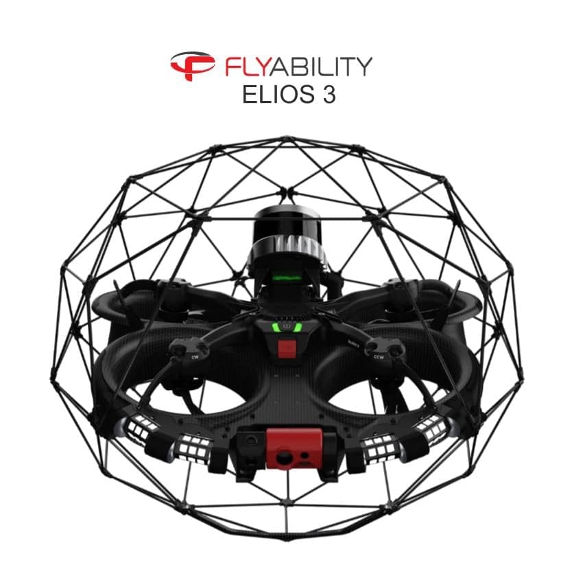
£40,000-60,000 GBP
The EVO II Dual 640T stands out as a cost-efficient, thermal-first option with a 640‑pixel thermal sensor and long flight time, giving operators high-resolution thermal detail for blade and gearbox hotspot detection at a lower acquisition cost than many enterprise platforms. While it lacks the broader enterprise ecosystem and redundancy of DJI’s flagship models, its superior thermal imaging per dollar and endurance make it a strong choice for teams prioritizing thermal diagnostics over heavy payload flexibility.

The Parrot Anafi Thermal is the budget-minded, ultra-portable choice for rapid spot-checks and small-scale solar inspections, prized for its lightweight folding design and straightforward thermal imaging workflow. While it lacks the industrial endurance and advanced geolocation of the Matrice line or the thermal resolution of higher-end dual-sensor units, its low acquisition and operating cost make it attractive for routine maintenance and occasional field teams.
The senseFly eBee X is a fixed-wing mapping workhorse ideal for large-scale corridor surveys and orthomosaic generation along long transmission lines, delivering the lowest cost per kilometer of coverage and long endurance when compared to rotary drones on this list. It is not designed for close-up, pole-level inspections — where DJI multicopters and the Autel excel — but it complements them by rapidly collecting high-accuracy photogrammetry and LiDAR across extensive networks, reducing overall survey time and manpower costs. Utilities that combine fixed-wing mapping for route-wide monitoring with multirotor detailed inspections gain the best financial and operational balance from including the eBee X in their fleet.
£12,000-£25,000 GBP
The Freefly Alta X is the market leader for heavy-lift, customisable inspection payloads and high-end LiDAR or cinematic-grade sensors, making it the choice for detailed asset scanning and complex BVLOS projects on UK rail corridors. While significantly more expensive and operationally intensive than the DJI and Autel platforms, its unmatched payload capacity and modularity deliver technical advantages for large survey contractors and infrastructure owners who need top-tier data quality for 3D modelling and rail asset management.
The Skydio X10 emphasizes industry‑leading autonomy and obstacle avoidance to perform close‑proximity inspections around complex rig structures with minimal pilot skill. Its automated flight and intelligent mapping reduce operator training and mission time versus manual platforms like the M350 RTK or Freefly Astro, delivering operational savings for repetitive, structure‑dense inspection tasks, though its payload and heavy‑sensor options remain more limited than high‑payload competitors.
Why inspection drones work: research and practical benefits
A growing body of research and industry trials supports the value of drone-based inspections. Academic studies, government-funded pilots and industry case studies show that drones can reduce inspection time, improve defect detection, lower costs and reduce the need for hazardous access methods. The combination of high-resolution imaging, thermal and multispectral sensors, and LiDAR produces data types that support condition assessment, predictive maintenance and environmental monitoring. In the UK, pilots funded by innovation agencies and collaborations between universities and utilities have demonstrated reliable workflows that meet operational and regulatory needs.
Safety and access: Multiple studies and operational case studies show drones reduce the need for personnel at height or in confined or hazardous spaces, lowering accident risk and avoiding costly access equipment.
Speed and cost: Industry reports indicate inspections that once took days can be completed in hours, enabling more frequent inspections and earlier detection of faults that would otherwise be more expensive to repair.
Detection and data quality: Sensors such as thermal cameras and LiDAR increase the ability to detect faults not obvious to the naked eye, improving accuracy of condition assessments and enabling predictive maintenance.
Environmental monitoring: Multispectral and thermal sensors are effective for mapping vegetation health, estimating crop stress and tracking habitat changes, supporting precision agriculture and conservation work.
Proven workflows: UK pilots and trials have demonstrated end-to-end workflows—from flight planning and data capture to processing and integration with asset management systems—that meet regulatory and data-security expectations.
Beginner-friendly tip: Typical inspection setups use three common data products — orthomosaic images for visual inspection, thermal maps for heat-related faults, and point clouds from LiDAR for precise structural measurement.
Frequently Asked Questions
Which inspection drone should I buy for pipeline surveys?
Choose the DJI Matrice 350 RTK, rated 4.7, because it has integrated RTK positioning for centimetre‑level geotagging and long endurance with multi‑payload support for dual thermal/visual inspections.
What sensor and positioning features does DJI Matrice 350 RTK include?
The DJI Matrice 350 RTK includes integrated RTK positioning for centimetre‑level geotagging of defects, plus long endurance and multi‑payload support for dual thermal/visual inspections.
How does Freefly Alta X price compare to DJI Matrice 30T?
The provided data includes ratings and features only—no prices are listed for Freefly Alta X or DJI Matrice 30T.
Is DJI Matrice 30T suitable for power-line fault detection?
Yes—DJI Matrice 30T has an integrated multi-sensor payload with thermal imaging and a high-resolution zoom camera tailored for power‑line fault detection, and it’s weather‑resistant.
Conclusion
Inspection drones are a practical, versatile solution for infrastructure, agriculture and environmental work across the UK. We hope this guide helped you understand why they are so useful and how to choose the right platform for your needs. If you want to narrow the results by sensor type, flight time, budget or regulatory readiness, use the search to refine or expand your options.